 |
|
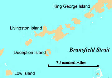 click map for more detailed location info |
Report 5 February - Team B on board Pelagic from Half Moon Bay to Deception
Friday 5th Feb 13.00pm
Special note:We would like to thank Clare Howes and Nathaniel Poulter from
Underhill School (Kent UK) for their good luck message. We received it today
via satellite.
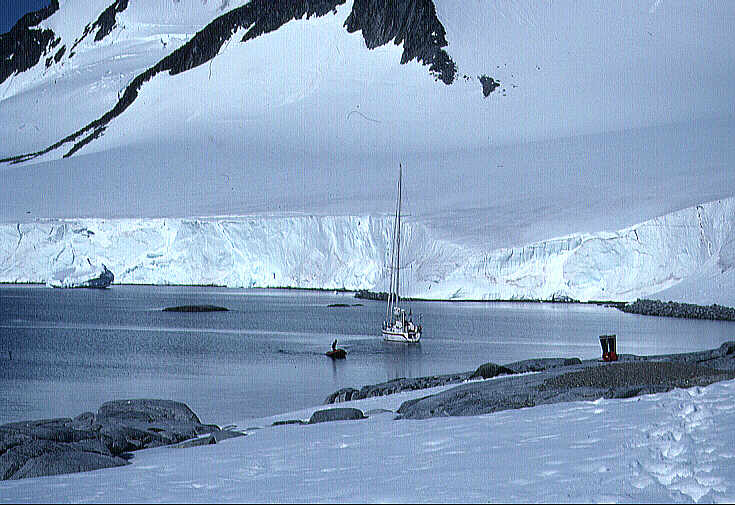 |
| Pelagic at Anchor. Click for full screen image. |
What time is it really? We have been changing it as we like it. Yesterday we
turned the clock two hours forward to make the most of the daylight. We
surprised Jerry, Eric and Troy who thought they had their first full night of
sleep by getting up at half past ten, though in fact it was two hours earlier.
So here we are living at minus one hour g.m.t.. Perhaps we will change the
clock again tonight to have a few extra drinking hours! The boys are very
happy, they just found another crate of beer. This morning we left Half Moon
bay to continue on our way to Deception Island.
Yesterday evening we had a very nice meeting with the argentinean navy aboard
the vessel Gurruchagga. Commander Castillo and his second chief Santiago
invited us for a drink and explained about their mission. They are operating as
a service-vessel, giving assistance to small bases in the Antarctic, cleaning
up oil spillages and helping ships in danger with for example metereologic
charts.
Heather is the happiest person aboard at the moment.after trying several sea
sickness pills, she eventually found the right ones. 'Since we left london I
haven't felt as good as i do now', she exclaimed, hugging Jerry for giving her
these magic pills.'Now I might even be at the helm on the Drake when we go back
to Ushuaia', she said optimistically.
At 23.38, we are anchored in Telephone Bay, Deception Island. The last volcanic
activity occurred here in 1992. Let's hope for the best!
In the coming days all of us will give short presentations on the sites we are
visiting. Kirsten did the first one on Deception Island.
"Deception Island is one of the largest
and most remarkable volcanic islands in the world. The name of the island comes
from the fact that the people who discovered the island were rather
disappointed when they found that the island was a mere perimeter of rocks
around a volcanic crater filled with water. The principal rock is lava. The
first person to explore the island in 1822 was the American sealer Nathaniel
Palmer although other sealers had called at Deception before.
You enter the island harbour through a narrow channel called Neptunes Bellows.
It is one of the safest harbours in the world, except during periods of
eruptions of course. In the first decades of this century the bay was much used
by whalers and sealers as a base for operations.
The British claimed the island to be theirs in 1908 and said that it was part
of the Falkland Dependencies. They leased the bay until 1931 to the Norwegian
whalers who operated up to twelve floating factories for the processing of the
dead whales. During the Second World War, the British destroyed all coal
resources and fuels on the island to prevent the Germans from taking it. There
were also quarrels between the British and the Argentineans and Chileans on the
question of who owned the island. After the war this problem was never
resolved. The three countries now have stations on the island and all claim it
is theirs. These claims are frozen by the antarctic treaty untill 2048.
There have been several volcanic eruptions in the last century. In 1920 the
water in the harbour started boiling and removed all the paint from the hulls
of the ships. In 1930 the harbour floor suddenly dropped 5 metres because of an
earthquake. In 1967 all stations needed to be evacuated because of a large
volcanic explosion in the vicinity of the Chilean base. All the people on the
island were saved but according to the base reports it was a very hazardous
event with snow and ice melting very, very fast and ash falling from the
sky,causing darkness.
We are looking forward to tomorrow. If the weather is good and the wind not too
icy, we might have a swim in one of the warm springs on the island.
Kirsten Kuipers
| Weather and Position Data | |||
| 1. Date | 2. Time | 3. Posn Long | 4. Posn Lat |
| 05/02 | 21.33 | 60°-41.340W | 62°-55.680S |
| 5. Compass Heading | 6. Wind Speed | 7. Boat speed | 8. Wind Dir |
| 3 Knots | 0 Knots | 60° | |
| 9. Pressure | 10. Air Temp | 11. Sea Temp | 12. Cloud Type |
| 984 | 3°C | no data | cumulus |
| 13. Cloud cover | 14. Precipitation | 15. Sea State | 16.Comments |
| 100% | light snow | calm | At anchorwind chill -8 |